By Andrea Jones, Director of Bird Conservation, Audubon California, and contributions from Victoria Elmore, Chris McCreedy, and Daniel S. Cooper
The Important Bird Area (IBA) Program is a centerpiece of Audubon’s conservation efforts, identifying the areas of highest priority to birds. While IBAs are not regulatory, they provide an important framework for conservation efforts statewide. A site’s designation as an IBA is a distinction used to leverage conservation efforts, increase opportunities for land acquisition, restoration, conservation planning, public outreach, advocacy, and environmental education, and, in some cases, may factor into establishment of legal protections for bird habitat.

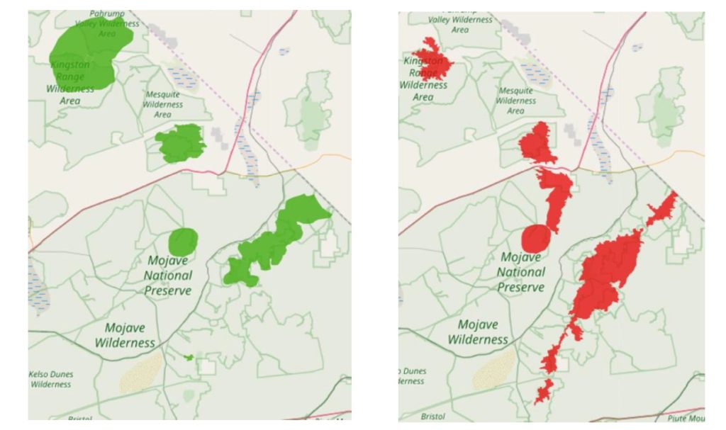
In 2008, Audubon California released maps of 145 terrestrial IBAs. However, periodically updating IBA data and maps through boundary modifications is necessary to reflect the best currently available science and for capturing on-the-ground changes. Since 2008, new research and mapping projects have emerged in California’s desert regions that suggest additional areas may qualify using the standardized criteria for designation as IBAs. For example, microphyll woodlands, which are known to have high habitat value to a wide array of species, were mapped extensively during the development of the Desert Renewable Energy Conservation Plan (DRECP), providing more accurate habitat data. Other areas, such as Antelope Valley, particularly important for Swainson’s Hawks, have experienced land use changes in recent years and its IBA needed to be reevaluated. Furthermore, in 2009, Point Blue Conservation Science released the Desert Bird Conservation Plan, which comprises the results of intensive bird surveys throughout the Mojave and Colorado deserts.
In recent years, the deserts have become a hotbed of renewable energy development, given solar, wind, and geothermal resources. While utility-scale renewable energy is an important part of a comprehensive climate change adaptation and mitigation strategy, it is important that developers avoid lands with the most critical habitat to birds and other wildlife. The IBA program has been central to Audubon’s Renewable Energy Program, which works with developers, lawmakers, and other stakeholders to help guide development to areas of least conflict. During the development of the DRECP, Audubon used IBA maps and data to inform its comments concerning renewable development area citing and to advocate for additional protections for high-value habitat.
With the support of a Sonoran Joint Venture Awards Program grant, in 2020 Audubon California updated the 2.4 million acres contained within 21 IBAs in California’s Colorado and Mojave Deserts. Based on the standardized IBA criteria, we used data from eBird, the Desert Bird Conservation Plan, recent published literature and reports, and expert opinion gathered from our regional contacts to refine boundaries, using elevation or habitat characteristics as a guide. Updated maps and revised text descriptions were uploaded into Audubon’s online Important Bird Areas database and are available at the links below.

Of the 21 IBAs, 14 had boundary changes. Two of these IBAs—Kelso Creek and Southern Sierra Desert Canyons—were merged into a single IBA but saw no net gain or loss of area. Eleven of these IBAs were increased in area, while only one IBA—East Mojave Peaks—was decreased in area. As a whole, the California desert IBAs saw a net increase of just under 200,000 acres. Mapping results showed that 50% of these IBAs are owned and/or managed by a Federal, State, or Local agency. Approximately 30% of the total land area are considered “conservation lands” including National, State, County, and City Parks, National Wildlife Refuges, Ecological Reserves, and private conservation lands. BLM lands not specifically managed for conservation were excluded, such as Off-Highway Vehicle areas.
Through a comprehensive update of the desert IBAs, Audubon improved the quality of a resource it not only uses to inform its own conservation advocacy, but also one it provides to partner organizations, agencies, and developers as we work together to build a sustainable future for both people and birds in the California deserts. In addition, Audubon is able to look closely at areas within the DRECP to determine the potential consequences of removing protections for and/or allowing development within them, using the resulting data to provide scientifically rigorous comments concerning the likely impact of such actions on the resident bird species. Finally, the update process highlights areas where gaps in data and/or knowledge exist, indicating a need for further action, such as coordinated bird monitoring. As climate change continues to impact the desert regions and species ranges contract or shift, period updates will be needed to ensure we are advocating for protection of the most critical areas for birds.
To view Audubon’s IBAs, visit the following links:

