By Bruce Orr, Senior Ecologist, Stillwater Sciences
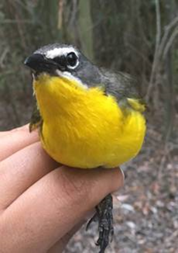
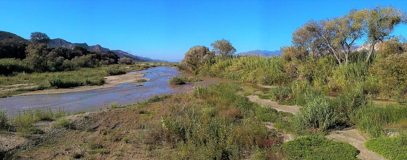
Conservation and restoration of California’s semi-arid river corridors is a daunting challenge, particularly in light of increasing demands for water and land coupled with global climate change. The Santa Clara River (SCR) is the largest river system in Southern California remaining in a relatively natural state and retaining much of its natural hydrology. Over 100 bird species have been documented using riparian vegetation along the Santa Clara River since 2010. “The Big 5” riparian bird species of concern on the Santa Clara River are Yellow-breasted Chat, Southwestern Willow Flycatcher, Yellow-billed Cuckoo, Least Bell’s Vireo, and Yellow Warbler. The relatively high species diversity for a river bounded along much of its length by agriculture and urbanization makes it notable for southern California. The watershed, which covers large portions of Los Angeles and Ventura counties, supports numerous rare natural communities and 38 special-status plant and wildlife species, including >20 that depend on the waters of the SCR and/or its associated riparian ecosystems. It also provides relatively intact patches of riparian and floodplain habitats, headwaters-to-ocean aquatic habitat linkages, and a regionally important north-south connection between protected terrestrial wildlife areas. However, portions of the SCR have been significantly altered by levees, water diversions, agriculture, and urbanization that have modified geomorphic and hydrologic processes, often causing aquatic and riparian habitat loss or degradation. The SCR was listed by American Rivers in 2005 as one of the most threatened rivers in the U.S. because of the juxtaposition of its environmental and conservation values with threats from urban and industrial development.
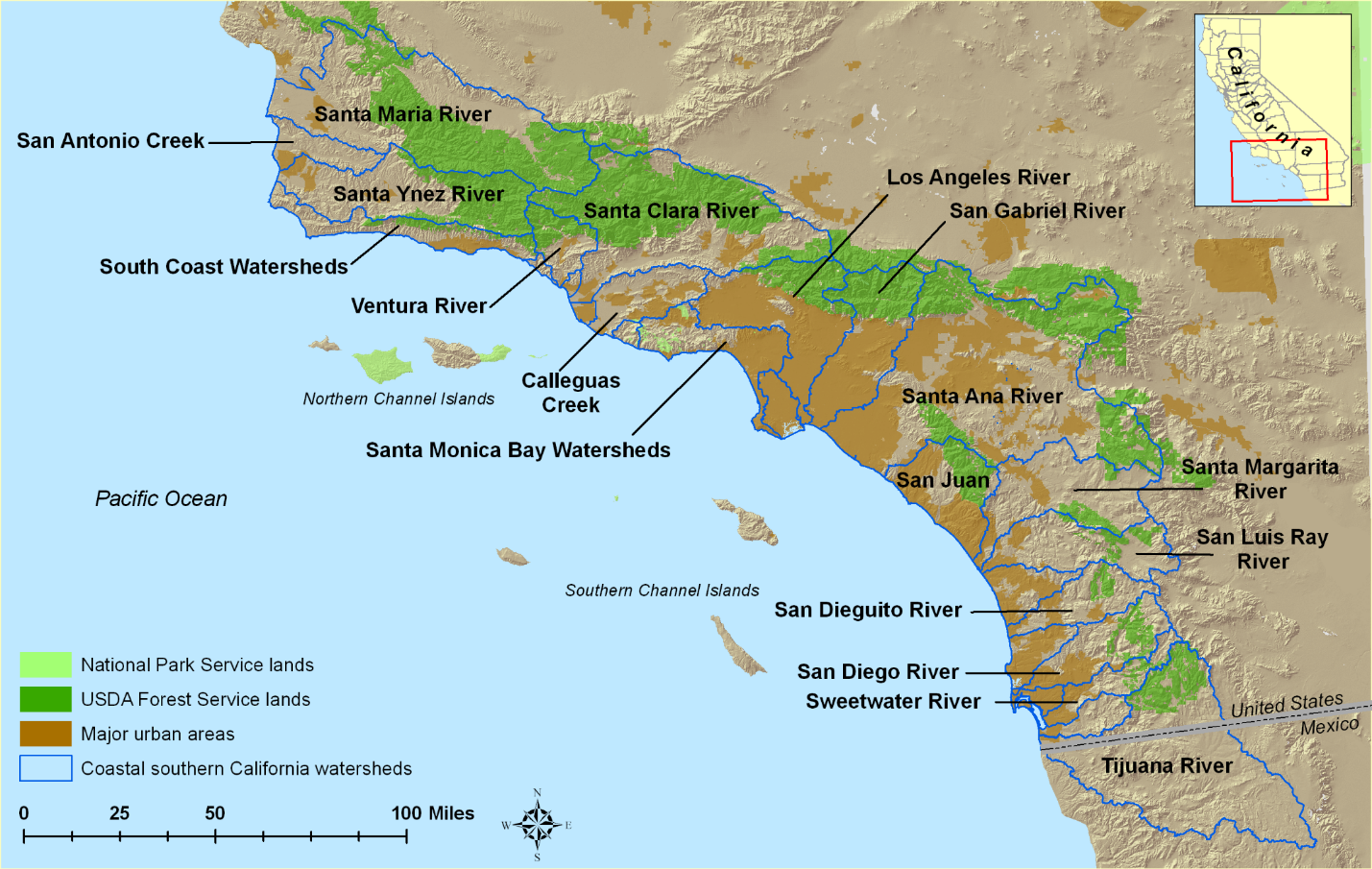
Because of its regional importance, the California State Coastal Conservancy, The Nature Conservancy, and numerous partners have been developing the Santa Clara River Parkway, which envisions a 30 mile-long floodplain corridor along the lower SCR in Ventura County (and ultimately may extend upstream another 20 miles into Los Angeles County) that ameliorates habitat degradation, conserves existing aquatic and riparian habitats, and provides for appropriate public access for recreation and education. The overall vision is to integrate ecosystem research, natural resource planning and management, and agricultural and commercial development to illustrate how science and regional planning may lead to cost-effective conservation of biodiversity and ecosystem functions, and sustainable communities.
Recognizing its importance as an example of approaches and lessons learned for multiple-benefit river restoration in California, the organizers of the Riparian Summit 2017 (click to access all the presentations listed below), which was held at UC Davis in October 2017, requested that we convene a special case study session focused on the SCR. This session included the following talks: (1) an overview of the Santa Clara River Watershed and its riparian and floodplain habitats, including assessment of current and historical conditions (Orr et al.); (2) a review of riparian bird species and their habitat along the SCR, plus some current monitoring and modeling efforts (Hatten et al.); (3) discussion of the Least Bell’s Vireo strategic habitat conservation planning effort for the SCR (Marek et al.); (4) a review of various techniques for floodplain protection and restoration that provides multiple benefits (Reige); (5) an update on development of a multi-species habitat conservation plan for the lower SCR (McCalvin); and (6) a review of the efforts undertaken by the SCR Steelhead Coalition (Meneghin), including a public outreach video, Santa Clara River: Restoring Resilience, that was shown at the end of the session.
Restoration, conservation, and research by the various SCR Parkway partners are continuing. One new area of focus is the influence of shallow groundwater on aquatic and riparian species and habitats, collectively referred to as groundwater dependent ecosystems (GDEs), and the long-term sustainable management of GDEs and groundwater supplies under the requirements of California’s recently enacted Sustainable Groundwater Management Act (SGMA). Another area of active investigation is exploration and application of technological advances in airborne laser mapping (also referred to as light detection and ranging or LiDAR) and other types of remote sensing. These advances are providing new tools for environmental assessment that can be used, in conjunction with focused field data collection, to conduct river floodplain and riparian assessments and restoration planning at multiple scales (e.g., river corridor, reach, and site scales).
For example, we are currently updating the existing vegetation classification and mapping data for the lower 50 miles of the SCR. These efforts are directly benefiting from the use of LiDAR to estimate stand and even individual tree canopy height along with relative elevation (height above the low flow river water surface, which can serve as a proxy for factors such as depth to groundwater which affects patterns of riparian plant distribution and establishment). The results of these efforts are being incorporated into habitat suitability models for the Southwestern Willow Flycatcher and Yellow-billed Cuckoo, as part of a study currently underway. We have also initiated a pilot study to explore the use of LiDAR to provide a more detailed estimate of vertical vegetation structure (from ground surface to top of canopy) that may be used in modeling habitat suitability for other riparian wildlife species, such as the Least Bell’s Vireo.